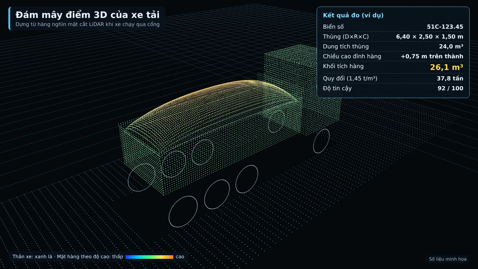
Measuring truck bed volume with LiDAR solves one specific problem: knowing exactly how many m³ of sand, soil, or stone each trip actually delivers without stopping the vehicle at the gate. Visual estimates or manual measurement of each trip produce a different number for every person and leave no evidence for acceptance. This article explains the point cloud scanning principle, installation conditions, the measurement process, and what needs to be prepared, based on An Ninh Số's Smart Box AI truck and barge volume measurement solution.
A steel frame gantry with LiDAR scans the truck bed from above as the vehicle passes underneath at under 15 km/h, building a 3D model of the cargo pile; an AI camera reads the license plate before and after at the same time. Each trip is measured twice, on entry with cargo and on exit empty: actual delivered m³ = entry m³ − remaining m³. An error of ≤ ±3% (for trips from 10 m³) is a proposed target, to be re-agreed by both parties based on the results of a 4-week trial run.
What are LiDAR and point clouds?
LiDAR (Light Detection and Ranging) measures distance using laser pulses: the sensor emits a beam, measures the time for the reflected beam to return, and derives the distance to the surface. When continuously scanning a moving object, each scan produces a cross-section; combining the cross-sections produces a point cloud, i.e., a very large set of points with spatial coordinates describing the shape of the surface.
For a truck bed, the point cloud reveals the shape of the bed walls, the bed floor, and the surface of the cargo pile. Unlike ordinary photographs, LiDAR measures distance directly, so it can build a 3D model of the cargo pile, including the portion of cargo protruding above the bed walls. This is the basis for calculating m³ from measurements instead of estimating by eye.
How a LiDAR volume measurement system works
A truck station consists of a steel frame gantry spanning the road, a LiDAR sensor suspended at about 8 m scanning the truck bed from above, AI cameras reading the license plate at the front and rear, an edge computer building the 3D model, and the Smart Box AI software. For long vehicles, the station includes an additional LiDAR for speed measurement.
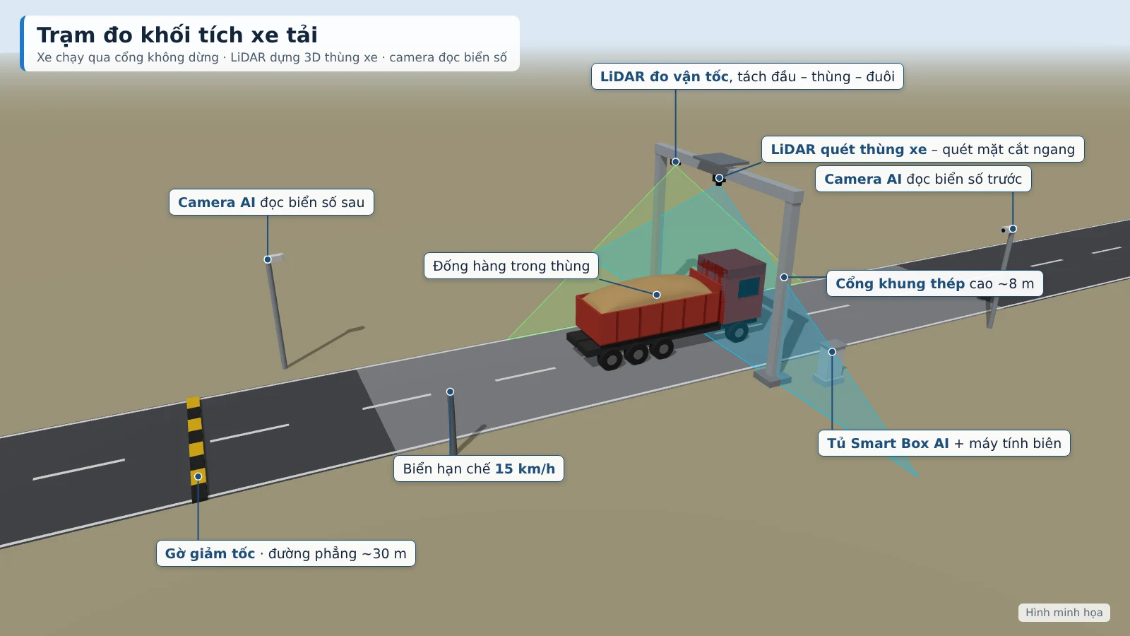
When a vehicle passes through the gantry at under 15 km/h, the LiDAR builds a 3D model of the truck bed and cargo pile. The system measures the length, width, and height of the bed and of the cargo pile, then calculates the m³ of cargo including the portion inside the bed and the portion protruding above the bed walls. The result is based on the actual surface of the cargo pile and is compared against the registered bed template of that specific vehicle.
The bed template is the key point. Each vehicle is registered once by passing empty through the gantry 3 times at different speeds. The system stores the bed interior dimensions and bed floor as the reference for all subsequent measurements, while also checking repeatability. When measured dimensions differ from the template, the software raises an alert for a suspected vehicle swap or raised bed walls.
Each measurement has a quality score from 0 to 100, calculated based on speed, occlusion level, and weather. A low-score measurement is automatically moved to a pending verification queue instead of being recorded as a normal result.
Technical requirements for system deployment
The measurement station requires suitable ground and infrastructure. The main requirements follow the truck station design:
- A galvanized steel gantry over the road, with a minimum clear height of 6.5 m, with a canopy for the sensors.
- A straight, level road section of about 30 m before and after the gantry, with speed bumps and a 15 km/h sign.
- 8MP cameras reading front and rear license plates, operating day and night.
- An additional LiDAR for speed measurement for long vehicles.
- An IP65 electrical cabinet with fan and dehumidifier, UPS, power and network surge protection, and grounding.
- Mains power or a generator; the station consumes about 1.5–1.9 kWh/day and runs 24/7. Where power is not available, a separate solar system can be offered as an add-on.
The steel structure is fabricated to actual dimensions after the survey. The station applies to 2–4-axle dump trucks and open-top semi-trailers carrying sand, soil and stone. At the security post, the recorder, TV and server of the existing camera system can be shared.
Truck bed volume measurement process
The measurement process takes place automatically when the truck passes the gantry, both on entry and on exit:
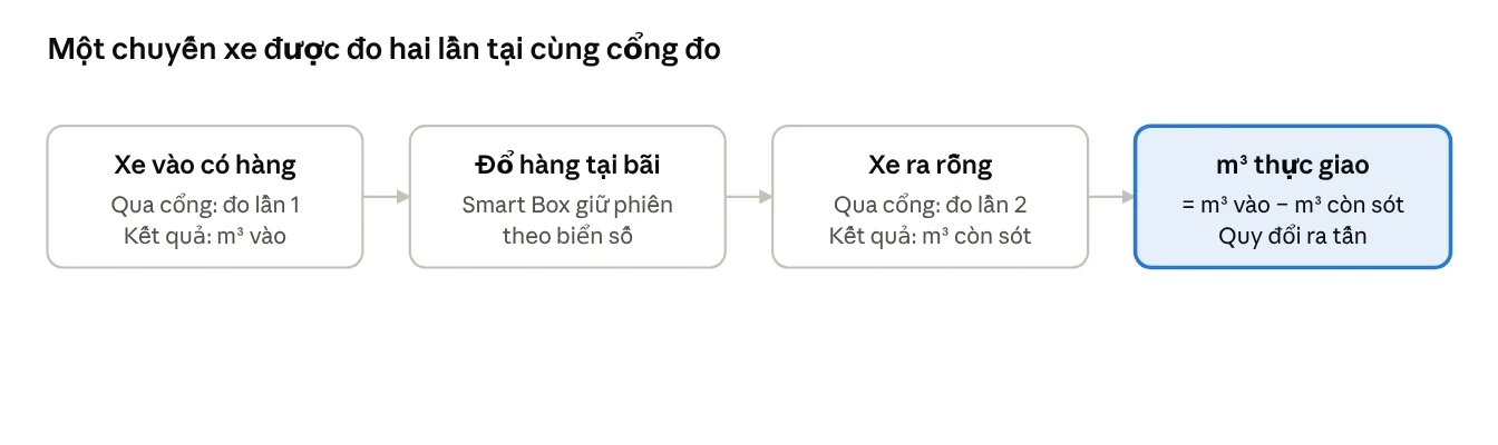
- The truck enters the measurement zone; the AI camera reads the front and rear license plates and captures the clearest photo of the pass.
- LiDAR scans the truck bed as the truck drives through the gantry; the truck does not need to stop.
- The edge computer builds a 3D model of the bed and the load, and calculates the m³ of material and the portion protruding above the bed sides.
- The system compares the dimensions with the bed profile, scores the measurement confidence and checks the warning thresholds.
- On exit, the gantry re-measures the empty bed; the system pairs the loaded entry pass with the empty exit pass of the same truck.
- The trip is closed with actual m³ delivered = m³ in − m³ remaining, together with converted tonnes according to the density table issued by the Investor.
The data for each trip includes license plate, contractor, entry time, exit time, time spent on site, bed and load dimensions, m³ in, m³ remaining, actual m³ delivered, converted tonnes, 3D model, photos and camera clips at the gantry, and the confidence score. A result time of ≤ 30 seconds is a proposed target, to be re-agreed by both parties based on the results of a 4-week trial run.
On tonne conversion: the density of sand, soil and stone varies with moisture and compaction, so the conversion factor needs to be issued by the Investor for each material type. If the site already has a weighbridge, integrating the data via API to track actual density over time is a project-based extension, configured during the survey of the existing weighbridge.
Key considerations for reliable measurements
The reliability of the measurements depends heavily on discipline at the gantry. These are the rules the Investor needs to issue to contractors:
- Open the bed cover before the measurement gantry.
- Drive at exactly 15 km/h, with only one truck passing the gantry at a time.
- Exiting trucks must also pass the measurement gantry to obtain the remaining m³ figure.
- Submit the full vehicle list of each contractor to register bed profiles.
When a truck is still covered, drives too fast or two trucks are too close together, the system reports "Unable to measure" and places the trip in the verification queue. Staff review the photos, 3D model and camera clips, then approve or adjust; all changes are logged and only the Investor may adjust the m³ figures.
Other warnings include underload (default below 85% of bed capacity), overheight (load more than 0.3 m above the bed sides), incomplete discharge (more than 0.5 m³ remaining on exit) and unknown vehicles not in the registered list. Thresholds are configured by the Investor.
Comparison table: traditional measurement methods vs. 3D LiDAR
Compared with manual measurement, 3D LiDAR measurement differs in three points: vehicles do not have to stop, every measurement has a 3D image and photo as evidence, and every trip is checked against that vehicle's own bed profile.
| Criterion | Manual measurement | 3D LiDAR |
|---|---|---|
| Measurement method | Visual estimation, manual measurement of each trip | 3D scanning of the truck bed as the vehicle passes through the gate |
| Vehicle requirements | Each vehicle must stop, prone to congestion at the gate | Passes through at under 15 km/h, no stopping |
| Accuracy | A different figure for every person | Proposed target ≤ ±3% (trips from 10 m³), to be re-agreed after the trial run |
| Time to result | Depends on the person measuring | Proposed target ≤ 30 seconds |
| Evidence | Handwritten records | License plate, photos, 3D image, clip, confidence score for each trip |
| Vehicle change, bed raised | Difficult to detect | Compared with the registered bed profile, alert on deviation |
| Residual material on exit | Usually not checked | Re-measured on exit, deducted from the actual m³ delivered |
Calibration before using measurements for payment
LiDAR measurements should only be used for acceptance and payment once the station has been calibrated on site and run for a 4-week trial. Calibration sequence for a truck station:
- Reference block: place a steel block of known dimensions under the measurement gate to align the sensors.
- Empty vehicle: each vehicle passes through 3 times at different speeds to establish the bed profile and check repeatability.
- Verification with a loaded vehicle: level the material flush with the top of the bed and measure manually; where a weighbridge is available, additionally verify by tonnage.
- Periodic: re-check with the reference block every month and after each relocation of the station.
Acceptance is based on 50 truck trips with verification over 7 consecutive days. The software exports a comparison table of measured m³, verification m³ and the error for each trip for both parties to sign off. Targets such as a measurement rate of ≥ 95% of trips, an error of ≤ ±3% for trips from 10 m³ and a time to result of ≤ 30 seconds are all proposed targets, to be re-agreed by both parties based on the results of the 4-week trial run.
An Ninh Số's Smart Box AI solution
Smart Box AI is developed by Việt Đức Trí Group, supplied and deployed by An Ninh Số, comprising a truck measurement station, a barge measurement station and trip management software on a server at the site. Notable points for the truck bed measurement problem:
- Each station processes locally and produces results on the spot; if the network is lost it still measures, buffers data for at least 7 days and automatically re-sends once connectivity is restored.
- Data is stored at the site and on the project's server; stations send results to the center via VPN.
- Device monitoring: alerts when the LiDAR signal, camera or power supply is lost, or when the sensor glass needs cleaning.
- Role-based permissions for the Investor, supervision, security, accounting and administration.
- Reports by day, shift, week, month, by contractor and by individual vehicle; reconciliation of vehicle counts between gates.
- Excel/CSV, PDF export and API to connect to the project's weighbridge or accounting software.
The Investor monitors via a web app on computer and phone; security staff view on a TV at the checkpoint and confirm trips flagged by the system. Full station configuration, software and specifications are available on the truck and barge volume measurement using LiDAR and AI cameras page.
Related solutions
Truck & barge volume measurement — Smart Box AI: 3D LiDAR and AI cameras measure m³ per trip, vehicles do not have to stop; each trip has a license plate, photo and 3D image as the basis for acceptance. View the solution, book an on-site survey →
Frequently Asked Questions
What is the error margin when measuring truck bed volume with LiDAR?
The proposed target is a volumetric error of ≤ ±3% for trucks (trips from 10 m³) and ≤ ±5% for barges, compared with the reference method. These are proposed targets, to be re-agreed by both parties based on the results of a 4-week trial run on site before acceptance.
What does the vehicle need to prepare before passing through the measurement gate?
The vehicle must open its bed cover before the measurement gate, drive at exactly 15 km/h, and only one vehicle may pass through the gate at a time. Outbound vehicles must also pass through the measurement gate so the system can calculate any remaining cargo. For barges, the speed through the measurement frame is 5 km/h following the channel markers.
Can the system measure at night?
Yes. The station operates 24/7, and the license plate cameras before and after operate day and night. Each measurement has a confidence score from 0 to 100 based on speed, occlusion level and weather; low-quality measurements are automatically forwarded to staff for verification.
What happens when a measurement fails?
The trip is placed in the verification queue along with the reason. Staff review the photos, 3D images and camera clips, then approve, adjust or reject. All changes are logged; only the Investor may adjust the m³ figures.
What if the network or grid power is lost?
Each station processes locally and produces results on site, so it still measures when the connection is lost, buffers at least 7 days of data and automatically resends when the network returns. The electrical cabinet has a UPS and power and network surge protection; the equipment monitoring reports immediately when power is lost or the LiDAR or camera signal is lost.
Can it connect to the weighbridge and the software currently in use?
Yes. The system exports Excel/CSV and provides an API to connect to the project's weighbridge or accounting software. Using weighbridge data to track actual bulk density over time is a project-based extension, configured during the survey of the existing weighbridge.
Can multiple measurement gates be installed within the same project?
Yes. The stations send results to the server at the construction site; the software reconciles vehicle trips across gates and consolidates reports by contractor and by individual vehicle. The number of stations and their locations are determined during the site survey.
Need LiDAR truck bed volume measurement for a construction site, mine or storage yard? An Ninh Số surveys the site, demonstrates the measurement method and proposes a station layout based on the actual site plan. Call the hotline 0796 700 777 or see the Smart Box AI truck and barge volume measurement solution.