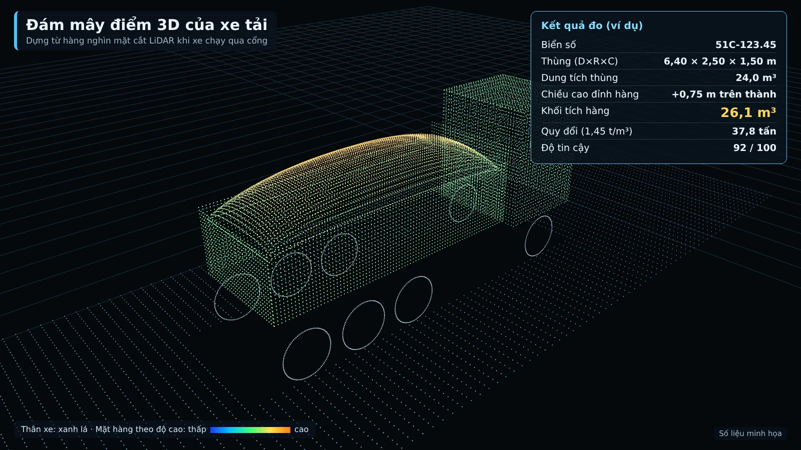
Monitoring mineral transport starts with a simple question: for every truck trip or barge trip leaving the mine site or entering the stockyard, how many m³ is it carrying. At many mines, ports and land-fill sites, this figure is still estimated by eye or measured by hand. Smart Box AI — the truck and barge volume measurement solution developed by Việt Đức Trí Group and supplied by An Ninh Số — records the license plate, photos, 3D image and actual m³ delivered for each trip using 3D LiDAR and AI cameras.
Smart Box AI measures the volume of each truck and barge trip using 3D LiDAR and AI cameras, with no need for the vehicle to stop. Each trip has a license plate or identification number, time, photos, a 3D image of the load and the actual m³ delivered, stored on the project server. This is a ready-made data foundation should the draft regulation on smart cameras at mineral transport points (03/2025, not yet in effect) be issued.
Mineral transport management requirements: law and draft
The 2024 Law on Geology and Minerals sets stricter management requirements for mining activities. Notably, the draft detailed regulation put out for consultation by the Ministry of Agriculture and Environment (03/2025) proposes installing smart AI cameras at locations where minerals are transported out of the mine site. This is a draft and is not yet in effect.
Under the draft, mining units install smart cameras at locations where raw minerals are transported out of the mine site. The cameras must be able to identify license plates and vehicles and connect to the data system on mineral activities. For extraction on rivers, lakes and seas, the draft proposes installing journey monitoring devices and cameras.
Because this is a draft, businesses are not yet obliged to apply its contents. However, the direction is clear: per-trip data — which vehicle, at what time, carrying how much — will increasingly be given importance. Smart Box AI already records the license plate, identification number, time, photos and m³ for each trip. Connection to the managing agency's system will follow official guidance once the regulation is issued.
The challenge at mine gates, construction sites and ports
Mines, land-fill sites, stockyards and inland waterway ports receive hundreds of trips per day. Without independent measurements, small per-trip discrepancies add up to large payment amounts and there is no evidence for reconciliation.
- Estimating by eye, measuring by hand trip by trip: every person gives a different figure, and there is no evidence for reconciliation at acceptance.
- Underloaded trips, incomplete discharge: trucks enter with material stuck to the bed and leave with material still remaining, yet are still counted as a full trip.
- Vehicle swapping, raised bed sides: beds are extended or vehicles with a different capacity than registered are substituted.
- Stopping the vehicle flow for checks: stopping each vehicle to measure causes congestion at the gate and delays site progress.
Monitoring mineral transport is therefore not just about installing license plate reading cameras. It is also necessary to know the volume of material on each vehicle, without slowing the vehicle flow.
How does the Smart Box AI solution work?
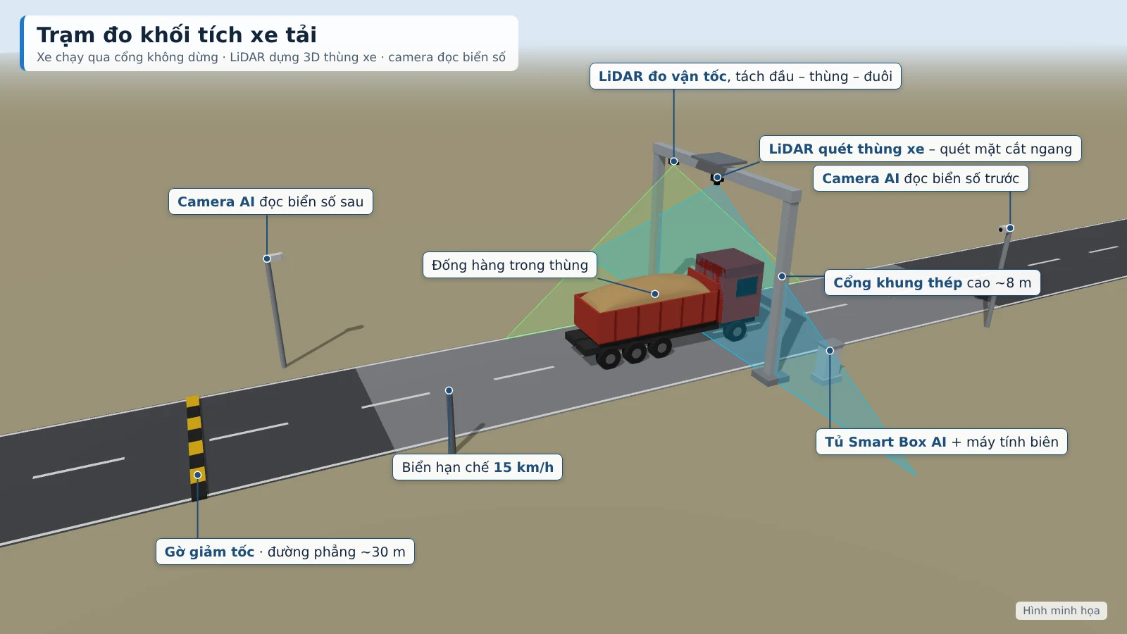
The system consists of two types of on-site measurement stations and one server at the construction site. Trucks pass through the steel gantry at under 15 km/h; barges pass through the measurement frame at under 5 km/h along the buoy line. LiDAR builds a 3D model of the truck bed or cargo hold, while AI cameras read the license plate or registration number at the same time.
Truck station
The station is installed at the entrance/exit gate of the construction site, mine or storage yard. LiDAR on the gantry scans the truck bed from above; 8MP cameras read the front and rear license plates, operating day and night. Each trip is measured twice at the same gate: on entry with cargo and on exit empty. Actual delivered m³ equals entry m³ minus residual m³.
Each vehicle registers its bed profile once by running empty through the gate 3 times. The system stores the bed interior dimensions and bed floor as the baseline for subsequent measurements, so it can detect when the bed has been raised with side extensions or when the vehicle has been changed. The station applies to 2–4 axle dump trucks and open-top semi-trailers carrying sand, soil and stone; the vehicle must open its tarp before the measurement gate.
Barge station
The station is installed at the channel into the wharf or import port, using two independent methods that cross-check each other:
- Barge enters the channel: the camera detects it, reads the registration number, and notifies security to confirm.
- The barge passes through the measurement frame at under 5 km/h; LiDAR builds a 3D model of the cargo hold and measures freeboard.
- The system calculates cargo m³: the portion inside the hold according to the registered hold profile, plus the portion of cargo protruding above the hold opening.
- The empty barge departs: the hold and freeboard are measured again.
- The difference in draft between entry and exit gives the tonnage of cargo; the system compares this with the tonnage converted from m³ and closes the trip.
Cargo is calculated against the barge's own hold opening, not against the water surface, so rising and falling tides do not distort the result. When the tonnage from 3D scanning and the tonnage from draft differ by more than 8%, the trip is forwarded to staff for confirmation.
Data recorded for each trip
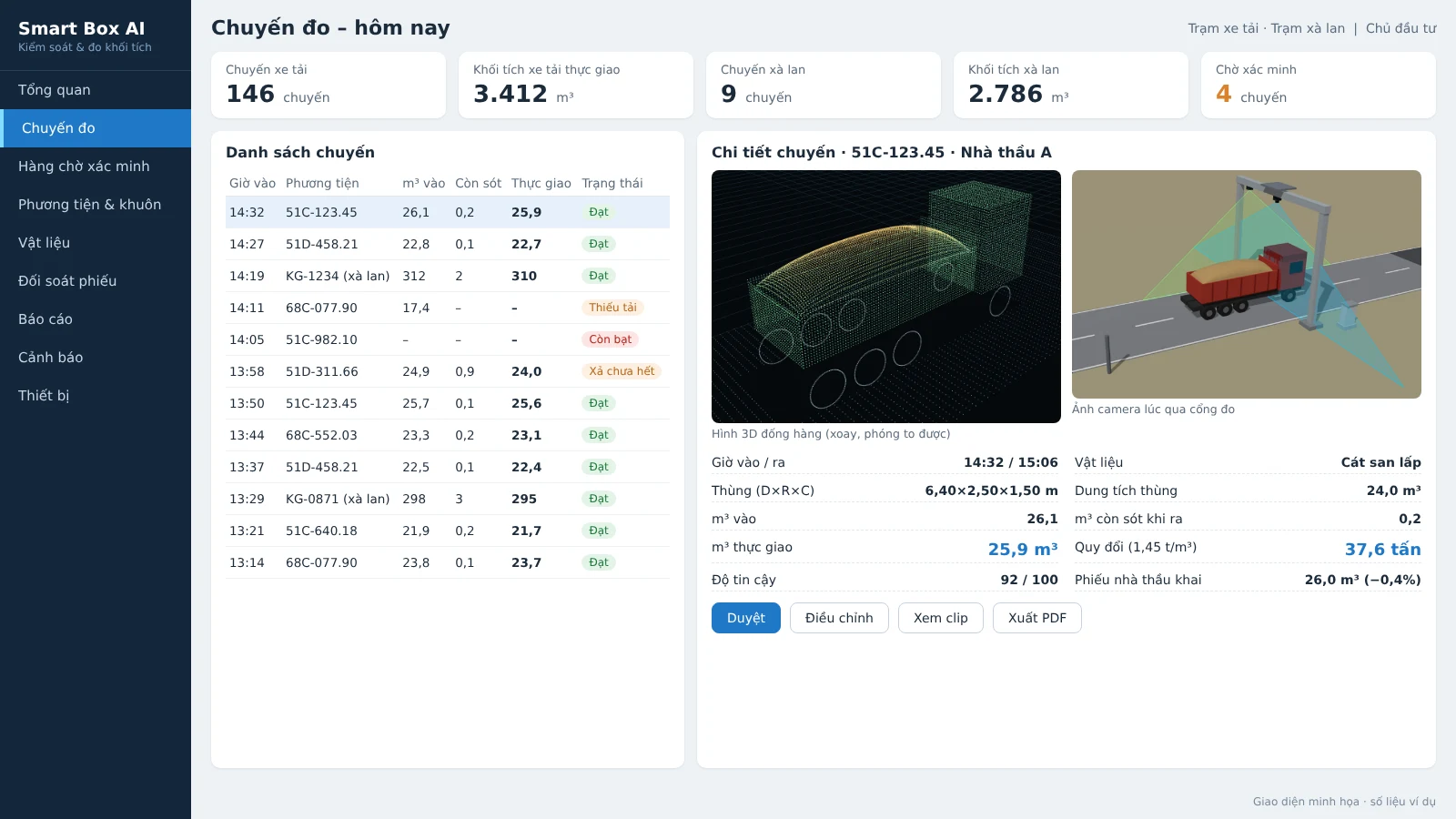
Each truck trip is a complete record: vehicle, time, dimensions, volume, converted weight, images and the confidence score of the measurement. This is exactly the type of data that mineral transport supervision requires.
| Data group | Recorded content |
|---|---|
| Vehicle | Front/rear license plate, contractor, clearest captured image |
| Time | Entry time, exit time, time spent inside the construction site |
| Dimensions | Length, width, height of the truck bed and of the cargo pile |
| Volume | Entry m³, residual m³, actual delivered m³, portion of cargo protruding above the bed sides |
| Weight | Tonnage converted by material type |
| Images | 3D model of the cargo pile, camera images and clips at the gate |
| Confidence | Measurement quality score (0–100) |
Tonnage is converted from m³ according to the density table for each material type issued by the Investor. The density of bulk materials varies with moisture and compaction, so this table needs to be updated by the Investor when the material source changes. For barges, the system additionally provides tonnage by draft for cross-checking.
Benefits of the automated monitoring system
Smart Box AI replaces estimated figures with measured figures backed by evidence, flags abnormal trips as soon as a vehicle passes the gate, and provides reconciliation reports with contractors. Data is stored on-site and on the project server, not uploaded to external services.
Instant alerts
Thresholds are set by the Investor. Alerts appear on the web app, on the TV at the security post, and are sent as messages to the responsible officers:
- Underloaded: cargo m³ below the registered level (default 85% of bed capacity).
- Over the side: cargo pile higher than the truck bed side by more than 0.3 m.
- Incomplete discharge: residual cargo above 0.5 m³ remains when the vehicle exits.
- Unable to measure: vehicle still covered by tarp, moving too fast, or two vehicles too close together.
- Unknown vehicle: license plate or registration number not in the registered list.
- Equipment: loss of LiDAR signal, camera or power; sensor glass needs cleaning.
Verification with an audit log
Each measurement is scored for confidence based on speed, occlusion and weather. Low-quality measurements are automatically moved to the verification queue. Officers review the image, 3D model and camera clip, then approve or adjust; every change is logged. Only the Investor may adjust the m³ figures; monitoring, security, accounting and admin roles have separate permissions.
Reports and reconciliation
- Volume by day, shift, week, month: number of trips, total m³, converted tonnes, split by truck and barge.
- By contractor and by individual vehicle: average m³ per trip, bed fill rate, number of underloaded trips.
- Payment reconciliation: declared m³, measured m³, variance, list of adjusted trips and the approver.
- System activity: share of trips measured, number of trips requiring verification, uptime of each station.
Reports export to Excel and PDF; data exports to Excel/CSV and an API is available to connect to the project's weighbridge or accounting software. Combining m³ with tonnes from the weighbridge to track actual bulk density over time is a project-based extension. The station keeps measuring when the network is down, buffers at least 7 days of data and resends automatically.
System deployment process
An Ninh Số conducts a site survey, installs the stations, calibrates on site, runs a 4-week trial, and only then carries out acceptance. Steel structures are fabricated to actual dimensions after the survey; the security post and the control center can share the recorder, TV and server of the existing camera system.
On-site calibration
- Reference block: place a steel block of known dimensions under the measuring gate and align the sensors.
- Empty vehicle: each vehicle passes through 3 times at different speeds to build the bed profile and check repeatability.
- Verification with a loaded vehicle: level the cargo surface flush with the bed side and measure manually; if a weighbridge is available, cross-check by tonnes as well.
- Barge: measure the hold profile when empty, compare with the registration records; cross-check by manual draft survey.
- Periodic: re-check with the reference block every month and after each relocation of the station.
Trial run and acceptance
Acceptance is based on 50 truck trips and 10 barge trips with cross-checks over 7 consecutive days. The software exports a comparison table of measured m³, reference m³ and error per trip for both parties to sign off. The volumetric error levels of ≤ ±3% (trucks, trips from 10 m³) and ≤ ±5% (barges), with result times of ≤ 30 seconds and ≤ 60 seconds, are proposed targets, to be re-agreed by both parties based on the results of the 4-week trial run.
What the Investor needs to prepare
- Site: locations for the measuring gate and measuring frame; a straight, level road section of about 30 m before and after the gate.
- Power: grid power or generator to the stations; if unavailable, An Ninh Số offers an additional dedicated solar system.
- Rules for contractors: open the tarp before the measuring gate; observe the correct speed of 15 km/h for trucks and 5 km/h for barges; one vehicle at a time; exiting vehicles also pass through the measuring gate.
- Vehicle list: list of trucks and barges for each contractor; barge registration records.
- Bulk density: table of bulk density by material type for converting m³ to tonnes.
Related solutions
Truck & barge volume measurement — Smart Box AI: 3D LiDAR and AI cameras measure m³ per trip, with no need for vehicles to stop; each trip has a license plate, image and 3D model as the basis for acceptance. View the solution, book a site survey →
Frequently Asked Questions
Common questions about mineral transport monitoring with Smart Box AI: operation during network loss, error margins, time to results, weighbridge connectivity, and periodic inspection.
To arrange an on-site survey and a Smart Box AI demonstration at your mine, construction site, or wharf, call the hotline 0796 700 777 or see details on the Smart Box AI truck and barge volume measurement page.