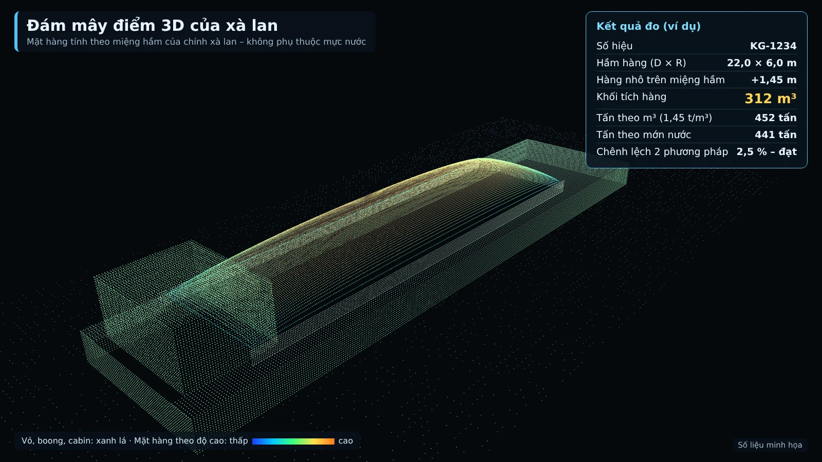
Calibration and acceptance testing of a LiDAR volume measurement system is the process of checking, adjusting, and confirming the accuracy of a bulk material volume measurement system before it is put into official operation. At mines, ports and yards, and land reclamation sites, the m³ figures for delivery and receipt are only accepted by both parties once the system has been calibrated with standard steel blocks, empty vehicles, and loaded reference vehicles, and then run for a 4-week trial on the actual route. This article is based on the process of Smart Box AI — the truck and barge volume measurement system developed by Viet Duc Tri Group, supplied and deployed by An Ninh So.
A LiDAR volume measurement system is only valuable when it is properly calibrated and acceptance-tested. The process consists of 5 calibration steps: standard steel blocks, an empty vehicle run 3 times at different speeds, a reference check with a loaded vehicle with leveled cargo, a barge hold template, and periodic checks every month; after that, a 4-week trial run is conducted before acceptance testing against the proposed criteria table.
What is calibration of a LiDAR volume measurement system?
Calibration is using known standards (steel blocks of known dimensions, an empty vehicle, leveled cargo measured manually) to check and adjust the LiDAR measurement system. Acceptance testing is the step where both parties confirm in writing that the system meets the agreed criteria after the trial period, serving as the basis for using m³ figures in delivery and receipt and payment.
Unlike weighbridges, a LiDAR volume measurement system does not measure weight but builds a 3D model of the truck bed, cargo hold, and cargo pile to calculate volume. Therefore, calibration must check multiple layers: sensor position and mounting angle, the empty template of each vehicle, measurement results when loaded, along with the ability to recognize license plates and identification numbers. A single measurement is not enough to conclude that the system measures correctly.
In this article, the error levels of ≤ ±3% for trucks (trips from 10 m³), ≤ ±5% for barges, the measured-trip rate of ≥ 95% (trucks) and ≥ 90% (barges), correct recognition of ≥ 98% during the day and ≥ 95% at night (trucks), and result time of ≤ 30 seconds (trucks) and ≤ 60 seconds (barges) are all proposed targets, to be re-agreed by both parties based on the results of the 4-week trial run.
5-step calibration process for the LiDAR volume measurement system
The Smart Box AI calibration process consists of 5 steps: (1) reference steel block; (2) empty vehicle runs 3 times at different speeds to establish the truck body template; (3) verification with a loaded vehicle with cargo leveled flush with the sides and manual measurement; (4) measurement of the barge hold template and verification by draft survey; (5) periodic checks with the reference block every month and after each station relocation. After calibration, a 4-week trial run and acceptance are carried out.
Step 1: Check with the reference steel block
Place a steel block of known dimensions under the measurement gate, have the system measure it and compare with the actual dimensions. The technician adjusts the sensors until the results match. This step handles installation-related deviations — mounting angle, sensor suspension height on the structure — before any vehicle passes through.
Step 2: Empty vehicle runs 3 times at different speeds
Each truck runs empty through the gate 3 times at different speeds, within the limit of under 15 km/h. The results are used to establish the "truck body template" — the inner body dimensions and bed of that specific vehicle — and to check repeatability between measurements. The truck body template is the reference for all subsequent measurements: when the measured dimensions differ from the template, the system warns of a suspected vehicle change or side extension.
Step 3: Verification with a loaded vehicle with cargo leveled flush with the sides
Select a loaded vehicle, level the cargo flush with the truck sides and measure manually to obtain a reference figure. Have the vehicle pass through the gate and compare the m³ measured by the system with the manual figure. Where a weighbridge station already exists, additionally verify by tonnage. Verification should be done with the actual materials of the site, since the surface and shape of the cargo pile differ by material type.
Step 4: Calibration of the barge station
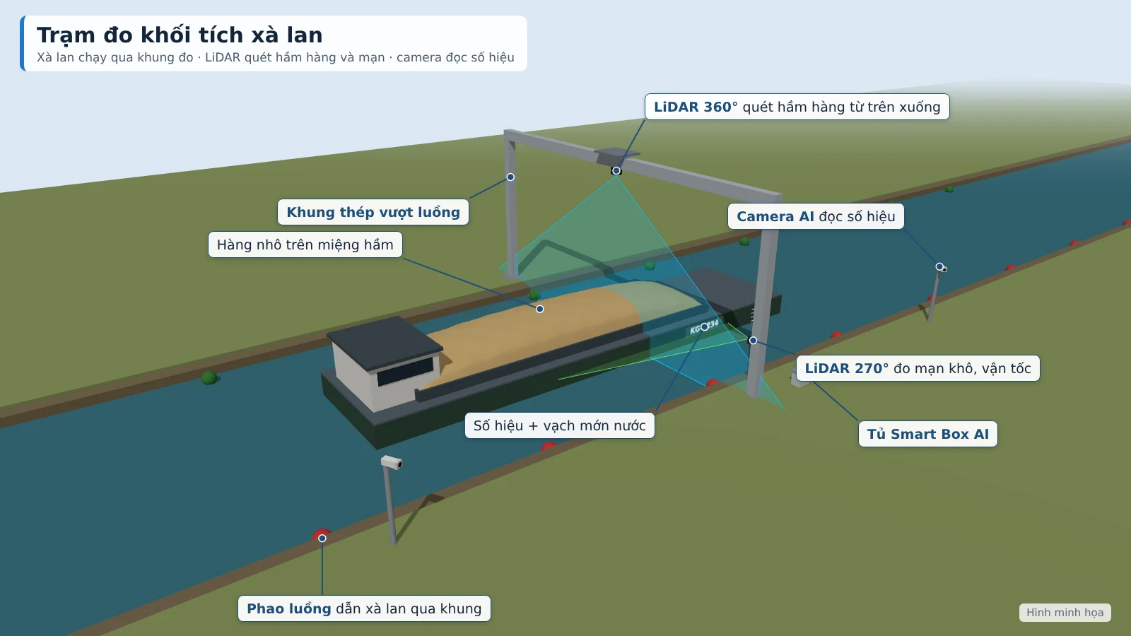
Measure the hold template of each barge when empty and compare with the registration records (hold dimensions, capacity, waterplane area). The measurement results when loaded are verified by manual draft survey. In operation, the system automatically compares the tonnage from the 3D scan with the tonnage from the draft; if the deviation exceeds 8%, it is forwarded to staff for confirmation.
Step 5: Periodic checks
Calibration is not done once and then forgotten. The station is re-checked with the reference block every month and after each station relocation. Between checks, the software monitors the LiDAR, cameras, power supply and connectivity, and alerts when the signal is lost or the sensor glass needs cleaning.
Proposed acceptance criteria table for the measurement system
The proposed criteria table is the starting point for both parties to agree on before the 4-week trial run. The criteria include the measured-trip rate, volume error, correct vehicle identification rate, time to result and station uptime.
| Criterion | Definition | Proposed target |
|---|---|---|
| Measured-trip rate (trucks) | Measured trips / trips passing the station as required | ≥ 95% |
| Measured-trip rate (barges) | Measured trips / trips passing the station as required | ≥ 90% |
| Volume error (trucks) | Deviation between the system result and the reference figure, for trips of 10 m³ or more | Proposed target ≤ ±3% |
| Volume error (barges) | Deviation between the system result and the reference figure | Proposed target ≤ ±5% |
| Correct truck identification | Rate of trips with the license plate read correctly | ≥ 98% daytime, ≥ 95% nighttime |
| Correct barge identification | Rate of trips with the registration number read correctly | ≥ 95% (with guard confirmation) |
| Time to result (trucks) | From the moment the truck passes the gate until the m³ figure is available | ≤ 30 seconds |
| Time to result (barges) | From the moment the barge passes the measurement frame until the m³ figure is available | ≤ 60 seconds |
| Station uptime | Time the station is operational during the month | ≥ 98%/month |
All the levels above are proposed targets, to be re-agreed by both parties based on the results of the 4-week trial run. They should not be written into the contract as fixed commitments before actual on-site results are available. In addition to the criteria table, the technical documentation states clearly that the station still measures when the network is down and buffers data for at least 7 days.
Implementation roadmap: survey, installation, 4-week trial run, acceptance
The roadmap consists of 4 phases: site survey, installation and calibration, 4-week trial run, and acceptance. Each phase has clear outputs that serve as the basis for moving to the next phase.
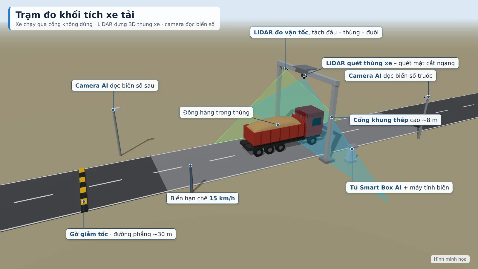
- Site survey: determine the locations of the truck measurement gantry and the barge measurement frame, vehicle flow, barge flow, power source, network connection and material types. The steel structure is fabricated to actual dimensions after the survey.
- Installation and calibration: the truck station uses a galvanized steel gantry frame spanning the road, with a minimum clearance of 6.5 m, sensors mounted at about 8 m, with a roof cover; the barge station uses a steel frame spanning the channel or a pillar with a 6–8 m cantilever arm, with the bottom of the frame at least 3 m above the barge side at high tide. Includes LiDAR, AI cameras, edge computers, an IP65 electrical cabinet with UPS and lightning protection. Then carry out the 5 calibration steps above.
- 4-week trial run: continuous operation on the actual route, full data recording for each trip, cross-checking against reference figures, review of measurements scored with low confidence, and logging of all adjustments.
- Acceptance: acceptance on 50 truck trips and 10 barge trips with reference figures over 7 consecutive days. The software exports a comparison table of measured m³, reference m³ and error per trip for both parties to sign and confirm, recording the agreed targets in the minutes.
What does the Investor need to prepare for calibration and acceptance?
To meet the measurement targets, the Investor needs to prepare the site, power, rules for contractors, a vehicle list, a specific gravity table and calibration coordination. Preparing these fully from the start helps the trial run reflect actual operating conditions.
- Site: locations for the truck measurement gantry and the barge measurement frame; a straight, flat road section of about 30 m before and after the gantry.
- Power: grid power or a generator to both stations; if unavailable, a separate solar system is quoted additionally.
- Rules for contractors: open the tarpaulin before the measurement gantry; observe the correct speed of 15 km/h (trucks), 5 km/h (barges); one vehicle at a time; exiting vehicles also pass through the measurement gantry.
- Vehicle list: list of vehicles and barges per contractor; barge registration records (hold dimensions, draft).
- Specific gravity: specific gravity table by material type for converting m³ to tonnes.
- Calibration coordination: arrange vehicles and barges for reference runs during the trial period; channel buoys and signage at the channel and the gantry entrance.
Measuring twice per trip and data storage: the foundation of acceptance
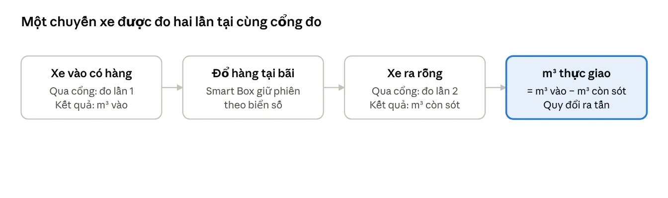
Each truck trip is measured twice at the same gantry: on entry with cargo and on exit empty; actual delivered m³ = entry m³ − residual m³. Empty barges on the return trip also have their hold and dry sides re-measured. Each trip stores the license plate or ID number, photos, 3D images of the cargo pile, camera clips and the measurement confidence score (0–100).
Measuring twice eliminates residual cargo in the bed, so the delivered m³ reflects the actual quantity of goods. The confidence score is rated based on speed, occlusion and weather. Low-quality measurements are automatically moved to a pending verification queue; staff review the photos, 3D images and camera clips, then approve or adjust, with all changes logged. Only the Investor may adjust the m³ figures.
At acceptance, this data is the evidence for cross-checking. The system operation report shows the measured trip rate, the number of trips requiring verification and the uptime of each station. Stations keep measuring when the network is down, buffer data for at least 7 days and resend automatically. Data is stored on site and on the project server, not sent to external services.
Common mistakes in calibration and acceptance
Common mistakes: skipping the standard steel block, running an empty truck only once, not cross-checking with a loaded truck, shortening the trial run, not keeping an adjustment log, and forgetting periodic checks. The consequence is that the m³ figures are not accepted by the receiving party, which easily leads to disputes.
- Skipping the standard steel block: calibrating only with an empty truck means deviations caused by sensor installation are not detected.
- Running an empty truck only once: repeatability at different speeds cannot be checked, and the bed profile is unreliable.
- Not cross-checking with a loaded truck: there is no way to know how accurately the system measures when there is real material in the bed.
- Shortening the trial run: there is not enough time to encounter different weather conditions, day/night, and different types of cargo, so the acceptance criteria are not close to reality.
- Not keeping an adjustment log: there is no basis for acceptance and for later traceability.
- Forgetting periodic checks: without re-checking with the standard block every month and after relocating the station, accumulated deviations are not detected.
Smart Box AI and the role of An Ninh Số in deployment
Smart Box AI is a truck and barge volume measurement system developed by Việt Đức Trí Group, supplied and deployed by An Ninh Số. The system uses 3D LiDAR, AI cameras to read license plates and hull numbers, an edge computer and centralized management software; data is stored on the project server. An Ninh Số conducts the survey, installation, calibration, a 4-week trial run and acceptance together with the Investor.
For details on station configuration, software and criteria, see the truck and barge volume measurement solution page. At the guard post and the control center, the recorder, TVs and server of the existing camera system can be shared; An Ninh Số surveys and integrates with the camera and vehicle gate control systems already in operation.
On the legal context: the 2024 Law on Geology and Minerals sets stricter management requirements for mining activities, and the Ministry of Agriculture and Environment has sought comments on a draft regulation (03/2025) proposing the installation of smart cameras at points where minerals are transported out of the mine site. This is a draft, not yet in effect; it should only be used for reference when planning.
You may also refer to Stable parking lot control equipment: 2026 solution selection guide and Apartment license plate recognition camera: 2026 LPR solution for an overall view of vehicle control infrastructure.
Related solutions
Truck & barge volume measurement — Smart Box AI: 3D LiDAR and AI cameras measure m³ per trip, trucks do not have to stop; each trip has a license plate, photo and 3D image as a basis for acceptance. View the solution, book an on-site survey →
Frequently Asked Questions
The questions below summarize common concerns from Investors, project management boards and supervision consultants regarding the calibration and acceptance of LiDAR-based volume measurement systems.
How long does it take to calibrate a LiDAR volume measurement system?
The on-site calibration time depends on the number of vehicles that need to be profiled and the number of comparison trips that the Investor can arrange. Calibration is followed by a 4-week trial run — the longest phase — before acceptance. The time for surveying, fabricating the steel structure and installation is finalized after the site survey.
Why is a 4-week trial run needed before acceptance?
The trial run must be long enough for the system to encounter various weather conditions, day/night, cargo types and traffic volumes. During this period, both parties review measurements that received a low confidence score, test the process for routing to verification staff and accumulate comparison trips. The final targets are agreed based on the trial run results.
Is the error target of ≤ ±3% for trucks a commitment?
No. The error of ≤ ±3% (trucks, trips from 10 m³) and ≤ ±5% (barges) is a proposed target, to be re-agreed by both parties based on the results of the 4-week trial run. Actual error depends on cargo type, speed through the measurement gate and site conditions. Both parties compare results with the comparison figures and record the agreed targets in the acceptance minutes.
Can the system measure when the network is down?
Yes. Each station processes independently and produces results on site, buffers data for at least 7 days and automatically resends once the connection is restored. Data is stored at the site and on the project server, not sent to external services; the stations send results back to the center via VPN.
Do trucks need to stop when passing through the measurement frame?
No. Trucks drive through the steel frame gate at under 15 km/h without stopping; barges pass through the measurement frame at under 5 km/h following the buoy line. Trucks must open their tarpaulin before the measurement gate and only one vehicle at a time; a truck still covered by a tarpaulin, moving too fast or two trucks too close together will be flagged as not measurable.
What data is stored for each trip?
For each truck trip, the system stores the front/rear license plate, contractor, entry time, exit time, bed and pile dimensions, inbound m³, residual m³, actual delivered m³, converted tonnes, 3D image of the cargo pile, photos, camera clips and the measurement confidence score (0–100). Low-quality measurements are automatically routed to verification staff, and every adjustment is logged.
What does the Investor need to arrange for the trial run?
The Investor arranges trucks and barges for comparison runs, buoys and signage on the channel and the access road to the gate; prepares the site, power supply, vehicle list with barge registration documents and a table of density by material type; and issues regulations for contractors on opening the tarpaulin, speed and passing through the measurement gate.
Does draft regulation 03/2025 require the use of a volume measurement system?
The draft regulation of the Ministry of Agriculture and Environment (03/2025) on smart cameras at points where minerals are transported out of the mine site is currently still a draft and not yet in effect. The draft content addresses smart cameras that identify license plates and vehicles, and does not directly require volume measurement. Investors should monitor it for updates when the official regulation is issued.
For a site survey, a Smart Box AI demonstration and advice on the calibration and acceptance process, contact An Ninh Số — hotline 0796 700 777, email [email protected]. See details on the truck and barge volume measurement solution page.