A license plate camera at the site gate can only answer which vehicle has entered. The investor needs more answers: how many m³ that vehicle is carrying, whether it has fully discharged, and whether the bed matches what was registered. When the license plate and the volume measurement are recorded at the same time, each trip has a record sufficient for reconciliation with the contractor.
This article explains how Smart Box AI measures the volume of trucks and barges combines an AI license plate reading camera with 3D LiDAR at the gates of construction sites, mines and storage yards, what the system records, the alerts, and how it is deployed.
Smart Box AI combines an AI truck license plate reading camera with 3D LiDAR at the gates of construction sites, mines and storage yards. Vehicles drive through the gate without stopping; each trip has a before and after license plate, photos, clips, a 3D image of the load pile and the actual m³ delivered. Unknown license plates, underloading and incomplete discharge trigger immediate alerts; data is stored on site and on the project server.
What is Smart Box AI?
Smart Box AI is a truck and barge volume measurement system developed by Viet Duc Tri Group and deployed by An Ninh So. An AI camera reads license plates, LiDAR builds a 3D image of the load pile, and software calculates the m³ of each trip without the vehicle having to stop for manual inspection.
The system addresses four familiar problems at land reclamation sites, mines, storage yards and inland waterway terminals:
- Volume is estimated by eye or measured by hand, with a different figure from each person and no evidence to cross-check at acceptance.
- Vehicles enter with a full bed and leave with material still remaining, yet are still counted as a full trip.
- Beds are enlarged or vehicles with a different capacity than registered are substituted.
- Stopping each vehicle for measurement causes congestion at the gate and delays the site schedule.
The license plate is the key that links this data together. Without a license plate, the m³ figure is just an isolated number; with a license plate, the m³ figure is tied to the vehicle, the contractor, the entry time, the exit time and the registered bed profile.
How the system works
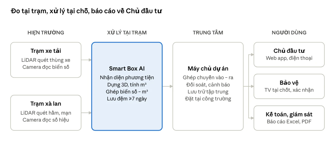
Each trip is measured twice at the same gate: on entry with a load and on exit empty. The camera reads the license plate before and after, LiDAR scans the vehicle bed; the software pairs the two passes of the same vehicle to calculate the actual m³ delivered.
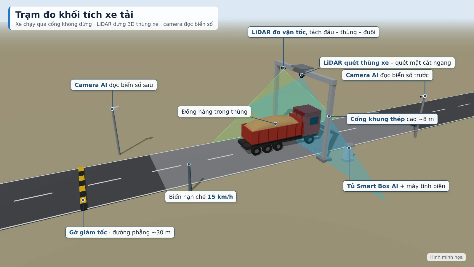
- Recognition: the vehicle drives through the steel frame gate at under 15 km/h; the AI camera reads the front and rear license plates, counts entry/exit passes by direction and captures the clearest photo.
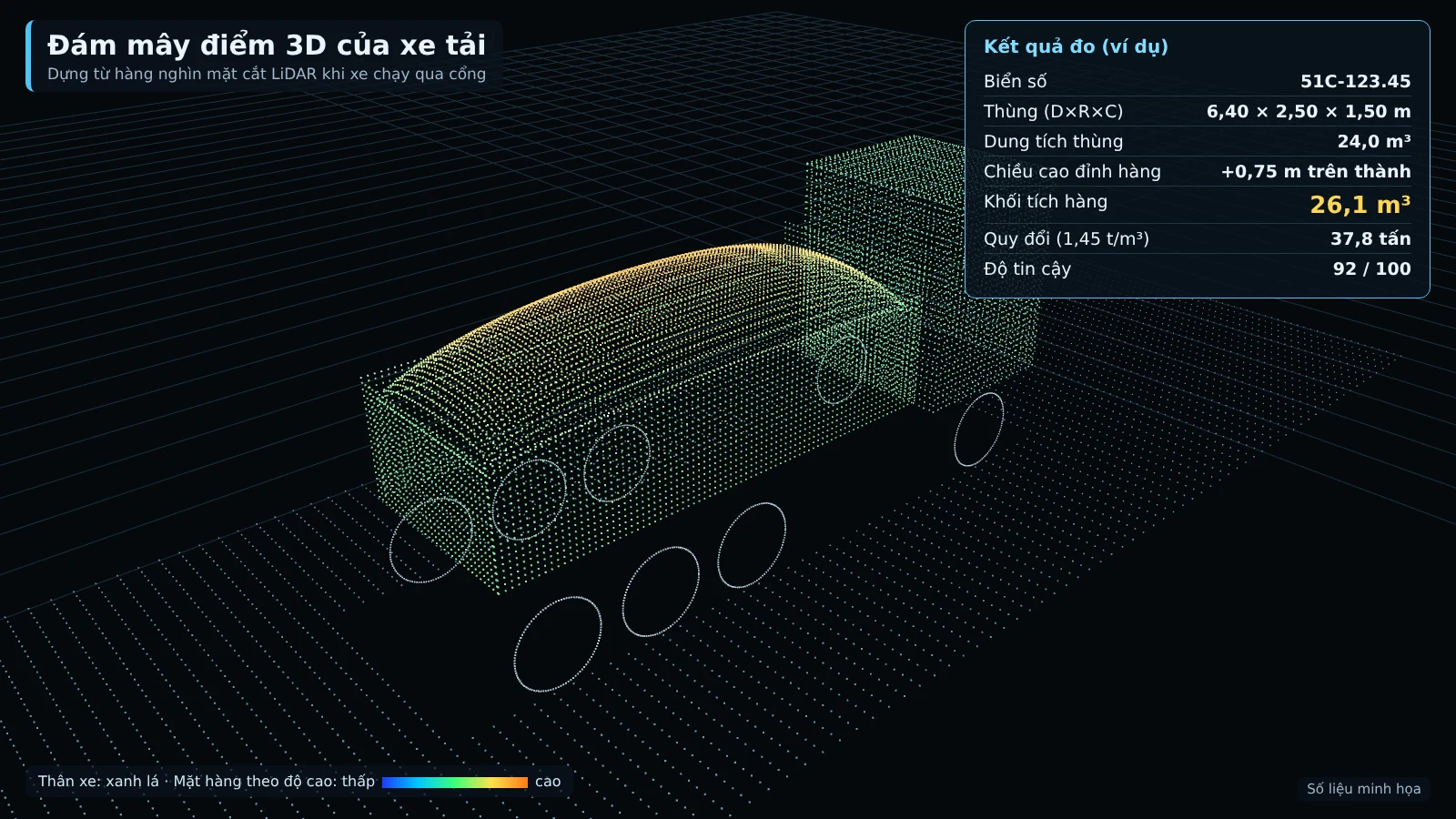
- 3D scanning: LiDAR on the gate scans the vehicle bed from above, creates a point cloud and builds a 3D image of the load pile; it measures the length, width and height of the bed and of the load pile.
- Bed profile comparison: the measured dimensions are compared with the registered bed profile for that same license plate; a deviation triggers an alert for a suspected vehicle substitution or raised sides.
- Trip pairing: the loaded entry pass is paired with the empty exit pass of the same vehicle; actual m³ delivered = m³ in − m³ remaining.
- Conversion and scoring: m³ is converted to tonnes using the investor's density table; each measurement has a confidence score of 0–100 based on speed, occlusion and weather.
Time to result is ≤ 30 seconds for trucks and ≤ 60 seconds for barges; volume error is ≤ ±3% for trucks (trips from 10 m³). These levels are proposed targets, to be re-agreed by both parties based on the results of a 4-week trial run.
The bed profile is established once per vehicle: the vehicle passes through the gate empty 3 times, and the system stores the inner bed dimensions and bed floor as the baseline for all subsequent measurements. The system applies to 2–4 axle dump trucks and open-top semi-trailers carrying sand, soil and stone.
Benefits of deployment at the site
The main benefit is that each trip has independent measurements with evidence, replacing estimates and disputes during acceptance.
- No vehicle flow obstruction. Vehicles pass through the gate at the correct speed; security staff only need to confirm the trips flagged by the system.
- m³ figures with a basis. Each trip has a license plate, photos, a rotatable and zoomable 3D image, a cross-section of the load, and a camera clip.
- Clear payment reconciliation. Reports compare declared m³, measured m³, and the difference, along with a list of adjusted trips and the approver.
- Tracking by contractor and by vehicle. Average m³ per trip, fill rate, number of underloaded trips; reconciliation of vehicle counts across gates.
- Complete electronic records. Every change to m³ is logged; only the Investor is allowed to adjust m³.
Regarding state management, the Ministry of Agriculture and Environment has solicited comments (03/2025) on a draft decree detailing the 2024 Law on Geology and Minerals, proposing the installation of smart cameras with AI license plate recognition at locations where minerals are transported out of the mine site. This is a draft and is not yet in effect. Connection to the management agency's system will follow official guidance once issued.
Alerts from license plates and measurements
Abnormal trips are flagged as soon as the vehicle passes the gate. Thresholds are set by the Investor; alerts appear on the web app, on the TV at the security checkpoint, and are sent as messages to the responsible officer.
| Alert | Condition |
|---|---|
| Unknown vehicle | License plate not in the registered list |
| Underloaded | m³ of cargo below the registered level (default 85% of bed capacity) |
| Over the side walls | Load higher than the bed side walls by more than 0.3 m |
| Incomplete discharge | More than 0.5 m³ remaining when the vehicle exits |
| Unable to measure | Vehicle still covered by tarp, moving too fast, two vehicles too close together |
| Equipment | Loss of LiDAR signal, camera or power; sensor glass needs cleaning |
Unknown vehicle alerts are only meaningful when the vehicle list is kept up to date. The Investor provides the list of vehicles for each contractor; the software's registry stores the vehicle, vehicle owner, contractor, and bed type.
System technical requirements
Each truck station is a complete set comprising a steel structure, sensors, cameras, a processing unit, and an electrical cabinet. The steel structure is fabricated to actual dimensions after the survey.
| Component | Truck station |
|---|---|
| Structure | Galvanized steel gantry spanning the road, minimum clear height 6.5 m, sensors suspended at about 8 m, with a roof |
| AI camera | 8MP camera reading front/rear license plates, operating day and night |
| LiDAR sensor | LiDAR scanning the truck bed from above; one additional LiDAR for speed measurement for long vehicles |
| Processing | Edge computer for 3D reconstruction + Smart Box AI |
| Electrical cabinet | IP65 cabinet with fan and dehumidifier, UPS, power and network surge protection, grounding |
| Measurement zone | Straight, flat road section of about 30 m; speed bump; 15 km/h sign |
| Power | About 1.5–1.9 kWh/day, running 24/7 |
On the site side, it is necessary to prepare the ground for the measurement gate, a grid power supply or generator (if not available, a separate solar system will be quoted additionally), and to stipulate with contractors: remove the tarp before the measurement gate, observe the correct speed, one vehicle at a time, and vehicles also pass through the measurement gate on exit.
Integration with existing systems
Smart Box AI leverages the camera infrastructure already available at the guard booth and control center, and can also connect to the project's software.
- Shares the recorders, TVs and servers of the existing surveillance camera system at the guard booth and control center.
- An Ninh Số surveys and integrates with the camera and vehicle gate control systems currently operating at the project.
- All data is stored on site and on the project's server; stations send results to the center via VPN.
- Excel/CSV export; API available to connect the weighbridge or the project's accounting software.
The investor monitors on computers and phones via the web app; guards at the booth view on TV and confirm trips on the spot. Role-based permissions: Investor, supervisor, guard, accountant, administrator.
Handling process for trips requiring verification
A measurement with a low confidence score or carrying a warning is automatically moved to the verification queue, along with the reason. Staff review the evidence and then decide.
- The trip is placed in the verification queue along with the reason (low confidence score, unable to measure, unknown vehicle, etc.).
- Staff review the recognition image, 3D image, cargo pile cross-section and camera clip.
- Staff approve, adjust or reject the trip; only the Investor may adjust the m³ figure.
- All changes are logged and appear in the payment reconciliation report.
Equipment incidents are handled separately: the system monitors LiDAR, cameras, power supply and connectivity, and alerts when the signal is lost or the sensor glass is dirty. When the network is down, the station still measures, buffers at least 7 days and automatically resends when connectivity is restored. Stability is maintained by re-checking the reference block every month and after each station relocation.
Related solutions
Truck & barge volume measurement — Smart Box AI: 3D LiDAR and AI cameras measure m³ per trip, vehicles do not need to stop; each trip has a license plate, image and 3D image as acceptance evidence. View the solution, book an on-site survey →
Frequently asked questions
How does the AI camera read truck license plates?
The vehicle drives through the steel frame gate at under 15 km/h, without stopping. 8MP cameras read the front and rear license plates, operating day and night, while the LiDAR on the gate scans the truck bed and builds a 3D image of the cargo pile. Each m³ measurement is linked to the correct license plate of that trip.
What is the accuracy of volume measurement and license plate recognition?
Volume error ≤ ±3% for trucks (trips from 10 m³), ≤ ±5% for barges; correct vehicle recognition ≥ 98% during the day, ≥ 95% at night for trucks. These are proposed targets, to be re-agreed by both parties based on the results of a 4-week trial run, before acceptance.
Can the existing camera system be reused?
Yes. At the guard booth and control center, the recorders, TVs and servers of the existing camera system can be shared. The measurement station itself requires a complete set: steel frame gate, LiDAR, AI cameras, edge computer and electrical cabinet.
If the network is lost, can the station still read license plates and measure?
Yes. Each station processes independently and produces results on the spot, buffers at least 7 days and automatically resends to the server when connectivity is restored.
At what speed do vehicles pass through the gate?
Trucks drive at exactly 15 km/h as indicated by the signage, one vehicle at a time, and must have the tarpaulin opened before the measurement gate. Vehicles still covered by a tarpaulin, driving too fast or two vehicles too close together will be flagged "Unable to measure" and moved to the verification queue.
Can it connect to the project's software?
Yes. The system exports Excel/CSV and has an API to connect the weighbridge or the project's accounting software.
To assess your construction site, mine or storage yard gate, An Ninh Số conducts an on-site survey (measurement gate location, power supply, vehicle flow, existing camera system), proposes a station configuration and gives a live demonstration of the Smart Box AI AI camera license plate reading and volume measurement solution. Contact the hotline 0796 700 777.